No products in the cart.
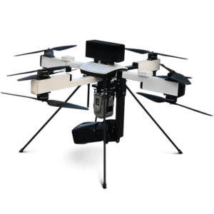
NPNT READY DRONE FOR DAY & NIGHT SURVEILLANCE WITH 40 MINUTES FLIGHT TIME AND 4 KM RANGE

Roll over image to zoom in
₹1,150,000.00₹1,200,000.00
inc GST
₹207,000.00 (+18% GST Extra)
- NPNT READY UAV is small category VTOL Unmanned Aerial Vehicle (UAV) based on our best-in-class drone technology. It is one of the most economical and efficient drone built with tried-and-tested military design philosophies.
- NPNT READY UAV can ideally be used for Security & Surveillance.
Item will be shipped in 4-6 weeks
Compare
Frequently Bought Together
-
NPNT READY DRONE FOR DAY & NIGHT SURVEILLANCE WITH 40 MINUTES FLIGHT TIME AND 4 KM RANGE
₹1,150,000.00₹1,200,000.00inc GST
(-4%)
₹207,000.00 (+18% GST Extra)

- This item: NPNT READY DRONE FOR DAY & NIGHT SURVEILLANCE WITH 40 MINUTES FLIGHT TIME AND 4 KM RANGE(₹1,150,000.00
₹1,200,000.00inc GST
(-4%))
₹207,000.00 (+18% GST Extra) - UGCS Mapper(₹40,000.00
₹48,500.00inc GST
)
₹207,000.00 (+18% GST Extra)
Technical Specifications:
- Endurance: 25–40 minutes @ MSL.
- Range (LoS): 2–4 km.
- Weight: < 3.5 kg.
- Wind Resistance: Up to 20 knots or 36 km/h.
- Max Operating Altitude: Up to 400 m AGL.
- Max Launch Altitude: 3000 m AMSL.
- Vehicle Size: < 1 m x 1 m.
Operational Characteristics:
- Launch & Recovery- Autonomous Vertical Take-Off and Landing (VTOL)
- Maximum space required for recovery: 25mX25m open area
Flight Modes:
- Fully autonomous from Take-Off to Landing without using any R/C controller.
- Altitude hold.
- Autonomous waypoint navigation (pre-defined as well as dynamically adjustable waypoints during flight times).
Deployment time (from fully packed state to UAV Taker –Off): <10 minutes.
Packing Time (after UAV landing to fully packed state): <10 minutes.
Fail Safe Features:
- Return to home on communication failure.
- Return to Home/Land on low battery.
- Multiple GPS on-board for GPS failure redundancy.
- High wind indication.
Packaging and Storage: Hard case for transportation and storage.
Operating crew: Maximum 2.
Communication Link Characteristics:
- Transmit control commands from GCS to UAV.
- Transmit telemetry data from UAV to GCS.
Frequency Band: 2.4 GHz to 5 GHz.
Ground Control Station Characteristics:
- Laptop (Windows OS with Bluefire patented software).
- GUI Display Parameters: Geographic map along with UAV location, UAV trajectory, camera view polygon, waypoints and Flight plans.
- Artificial Horizon indicating UAV altitude.
Maps:
- Capability to works with Google maps and/or other available open source maps. Application should have
the capability to download maps automatically after specifying the location GPS co-ordinates. - Capability to integrate geo-referenced raster maps provided in at least one of the commonly used digital maps format. (gif, tiff etc.).
User Controls:
- One click Take-Off/Land/Hover.
- Set altitude of UAV.
- Waypoint navigation.
- Dynamic flight plan adjustment.
- Point payload to ground co-ordinate function.
Joystick control:
- RPV mode.
- Altitude control.
Pre Flight checks: Capability to perform pre-flight checks of the complete system before every flight for confirming the suitability of flight worthiness.
Payload:
- Thermal Payload (Black/White hot): 320 x 240 pixels, 640 × 480 pixels (Optional).
- Thermal Payload: 640 × 480 pixels (Radiometric).
Additional information
| Weight | 0.005 kg |
|---|---|
| Dimensions | 0.001 × 0.001 × 2.95 cm |
No more offers for this product!
General Inquiries
There are no inquiries yet.
Reviews
There are no reviews yet.